FAKED APOLLO MAN ON THE MOON PHOTOGRAPHS by 'Exorcist'
Hi 'Exorcist' and welcome. I'll do my best to copy your photos, upload them, and make them visible here, if that's OK with you.
Could you do us a favour and repost your material here, bearing in mind we discourage spammers, so you won't get the absurd nonsense endemic in the forum you posted on. Also, we could make a Youtube or two based on your material - is that OK with you?
I'm assuming your material is convincing!
PS why not give an account of your discovery on nuke scepticism in the welcome part of the forum?
NB I've tried to make the 'Subject title' heavy on keywords.
FAKE APOLLO MAN-ON-MOON PHOTOGRAPHS by 'Exorcist'
6 posts
• Page 1 of 1
-

rerevisionist - Site Admin
- Posts: 1056
- Joined: 18 Mar 2011 11:40
Re: FAKE NUCLEAR TEST FILMS-FAKE APOLLO PHOTOGRAPHS
Hi rerevisionist
I have no problem with your suggestion. Feel free to use or distribute them as you wish. I mentioned the annotation has been updated which also includes the correction of one spelling mistake typo. I'll Email you the updated drawings now.
I have no problem with your suggestion. Feel free to use or distribute them as you wish. I mentioned the annotation has been updated which also includes the correction of one spelling mistake typo. I'll Email you the updated drawings now.
-

Exorcist - Posts: 73
- Joined: 08 Jan 2012 14:21
- Location: UK
Re: FAKE NUCLEAR TEST FILMS-FAKE APOLLO PHOTOGRAPHS
Rerevisionist
Updated drawings Emailed. Regarding whether they are convincing or not they have been on the BDF for 3 months now and no one has attempted to refute them. I am 100% certain my analysis is correct. It relies on simple geometry which people educated to Maths "O" or "A" level can easily understand. I have also posted links to them on YouTube as FINTINLINBIN where I was assailed by the usual NASA lie supporting dog pack. However when I challenged them to refute them on the BDF they used every excuse in the book to avoid doing so saying they couldn't be bothered. I'm confident they visited the forum, studied the drawings and realised they were on a loser.
Updated drawings Emailed. Regarding whether they are convincing or not they have been on the BDF for 3 months now and no one has attempted to refute them. I am 100% certain my analysis is correct. It relies on simple geometry which people educated to Maths "O" or "A" level can easily understand. I have also posted links to them on YouTube as FINTINLINBIN where I was assailed by the usual NASA lie supporting dog pack. However when I challenged them to refute them on the BDF they used every excuse in the book to avoid doing so saying they couldn't be bothered. I'm confident they visited the forum, studied the drawings and realised they were on a loser.
-

Exorcist - Posts: 73
- Joined: 08 Jan 2012 14:21
- Location: UK
Re: FAKE NUCLEAR TEST FILMS-FAKE APOLLO PHOTOGRAPHS
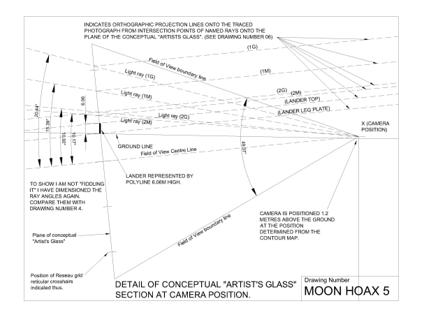
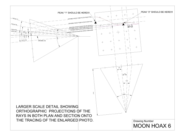
Exorcist - thanks for the diagrams. I've put them on imgur.com (an image sharing program) and also made 20% thumbnails, all 6 of which follow. The full size drawings' addresses are listed at the end. If you wish, use these as a basis for your explanations. (I can delete this message if you like later - it's basically to get the addresses to you),
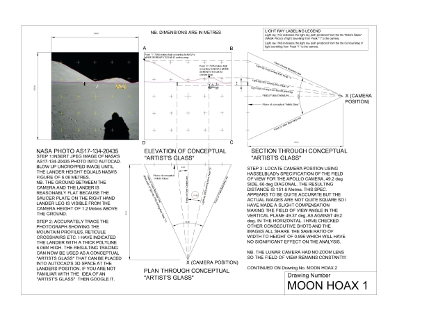
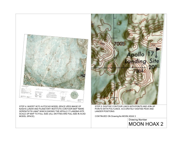
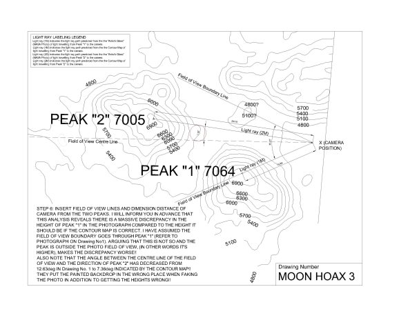
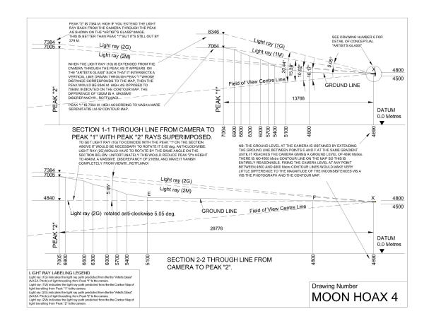
The full size images are on
https://i.imgur.com/fZiaa.jpg MOON HOAX 1
https://i.imgur.com/57elz.jpg MOON HOAX 2
https://i.imgur.com/6EQSB.jpg MOON HOAX 3
https://i.imgur.com/aC77a.jpg MOON HOAX 4
https://i.imgur.com/Cn9po.jpg MOON HOAX 5
https://i.imgur.com/OpzCw MOON HOAX 6


The full size images are on
https://i.imgur.com/fZiaa.jpg MOON HOAX 1
https://i.imgur.com/57elz.jpg MOON HOAX 2
https://i.imgur.com/6EQSB.jpg MOON HOAX 3
https://i.imgur.com/aC77a.jpg MOON HOAX 4
https://i.imgur.com/Cn9po.jpg MOON HOAX 5
https://i.imgur.com/OpzCw MOON HOAX 6
-

rerevisionist - Site Admin
- Posts: 1056
- Joined: 18 Mar 2011 11:40
Re: FAKE APOLLO MAN-ON-MOON PHOTOGRAPHS by 'Exorcist'
I just noticed (in an Iranian news site) that China claims to have produced the highest-ever resolution map of the entire moon. I don't take this kind of thing very seriously now. It's not even entirely clear whether it covers the 'dark' side, i.e. the side away from earth. NB a recent video (search Youtube for 'first ever video of dark side of the moon released by Nasa') suggests some effort is being made to revive interest in the moon. (First ever Nasa video? After 50 years of supposed travel to the moon?) The Chinese claim the first complete lunar map from images with a resolution of 7 meters or better but 'resolution' may just mean one pixel - it's not clear. The main point is, their stitched photos are supposed to cover the entire moon; the clearest moon images yet, released by the United States, have a resolution of less than half a meter, but they do not cover the entire moon - no prizes offered for which bits are omitted.
Google e.g. china high resolution moon map.
Google e.g. china high resolution moon map.
-

rerevisionist - Site Admin
- Posts: 1056
- Joined: 18 Mar 2011 11:40
Re: FAKE APOLLO MAN-ON-MOON PHOTOGRAPHS by 'Exorcist'
I saw this some months ago. You can purchase the data IIRC for £30 or you have to subscribe. As you mention, the abstract (it was a scientific paper) is not very clear on the nature of the improvement, the error parameters and the form in which the data is provided. I need raster map images to insert into AutoCad.The discrepancy I found between the South Massif's height in the photo and it's height on the NASA contour map is so enormous (1080m), I felt repeating the work with the Chinese map (if you actually get access to maps by purchasing the Paper) would be a waste of my time and unlikely to produce a significantly different result. To put the results of my analysis in simple terms ground level at the lander is 4690m, the peak of the "fake painted backdrop" South Massif in the photo is 3656m higher than the lander, whereas, according to the contour map it should be 2374m higher ie it appears ~50% higher than it should do.
There are a number of NASA liar "spoofs" on YouTube trying desperately to prop up the "Man on the Moon" myth. I've had encounters with a few of them eg knowledgemonger, spreadingthemuse and ytmoog. I'll put up a few posts later illustrating some of their desperate failed attempts to refute my analysis ....lol
https://ieeexplore.ieee.org/xpl/freeabs_all.jsp?arnumber=5783918
-

Exorcist - Posts: 73
- Joined: 08 Jan 2012 14:21
- Location: UK
6 posts
• Page 1 of 1
Return to Movies, Stills, Soundtracks: Check the Media Yourself, for Fakes & Lies!
Who is online
Users browsing this forum: No registered users and 1 guest